Monday, September 27, 2021

Honey Creek Loop

Honey Creek Loop

Big South Fork 

5/15 - 5/16/21 (1 night)

2021 Bag Nights: 5

I offered to help plan a trip for someone online who had never been to Big South Fork. The process of thinking about trips made me decide that I needed to revisit the area. 

I started up top at the East Rim Overlooking parking area since there had been recent flooding and I was worried that the Leatherwood Ford area would be shut. When I got down there, there were signs of high water but parking would have been no problem. Oh well, I had an extra couple miles of hiking, but they were good miles. 

Mountain Laurels were blooming


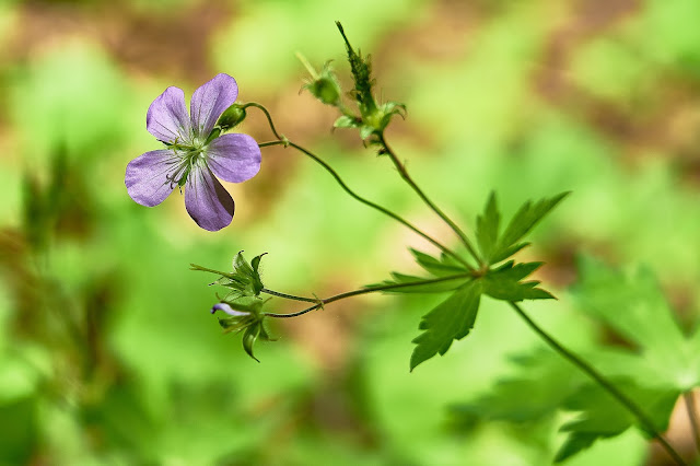
I think this is Wild Geranium


Sweetshrub or Calycanthus, I've been told this is rare, I've only seen it in Big South Fork.

The Big South Fork of the Cumberland River

On the other JMT

Nice waterfall a couple miles into the hike


View from the O&W bridge

Jake's Falls

Pink Lady Slipper


Needles Eye or Hole in the Rock


Honey Creek Loop, the trail is a little wet in places

I got to the area I was planning on camping and found it already occupied. But they invited me to setup nearby and I ended up sharing their campfire and chatting for a couple hours. 

Weird Rock in the river (edit: thanks to Georgia Yankee on backcountrypost.com for identifying this as Lepidodendron fossil. More info here - https://samnoblemuseum.ou.edu/common-fossils-of-oklahoma/plant-fossils/fossils-by-plant-group/fossil-lycophytes/)


I climbed up to see the Honey Creek Overlook. The last time I was here there was too much fog/rain to see anything.


Eastern Columbine

Iris

Honey Creek Falls

Different angle

Ice Castle Falls

Secluded Falls

View from an unofficial trail. I ended up chatting with a couple horse people here for a little bit.

And a couple hours later, I was back at my car. This was a great 30ish hour trip with just a few more people than I would normally prefer. 

Cades Cove

Cades Cove 
Great Smoky Mountains  
January 10 - 14 (4 nights)
2021 bag nights: 4

I don't tend to go car camping by myself, especially in one of the largest campgrounds in the country's most popular national park. But, the weather looked really wet for backpacking and I had the idea of checking out Cades Cove in the GSMNP in the off-season so maybe the crowds would not be too bad. 

Home for the next couple of days, big tarp, a couple piles of firewood, a cooler full of beer, my bike, ... all the comforts of home (except for electric heat). 

I set up camp and then went for a ride. It had snowed up high the night before, so the mountains were looking very pretty.


John Oliver Place


Methodist Church


There was a solo guy playing guitar and singing in the church. He sounded great and really made it easy to imagine what the church would have sounded like 100 years ago.

I was getting annoyed with the traffic and getting cold riding my bike, so I cut across the valley on one of the middle roads vs. riding the whole loop.

Dan Lawson Place

Carter Shields Cabin

A couple grave sites


The next morning it was snowing, so I drove over to the Primitive Baptist Church. 

I wasn't there long before a Park Ranger drove up and said that the Park was shutting the gates because the forecast called for a lot of snow. 

Somewhat disappointed, I headed back to my site, on my way I passed the Carter Shields Cabin again. 

And then I went for a hike. I decided that the Rich Mountain Loop trail over to Rich Mountain Road sounded like a good idea and then I could walk the Cove Road back to camp. I ended up not taking any photos during the hike and when I got back to the Cove Road, there were cars. Evidently the Park Service decided that there was not going to be a lot of snow and reopened the gates. 

So, back in my car to explore some more. 

The Elijah Oliver Place is a large group of buildings, including and house, barn and chicken coop. This is the barn.


The back of the house


This is the Cable Mill

Old mill stone

Mill Run

The next morning was heavy fog, no sign of the sun, but still pretty


Old cemetary


Lots of children grave sites

From the above grave stone, Robert was born in 1774, so 37ish years older than his second wife. And she lived another 44 years after he died in 1860. 

One of the crossroads in the Cove is Sparks Lane.

I took advantage of the lack of crowds to hike to Abrams Falls. In the summer time, this area is crawling with people. Today, I passed about 4 groups of dayhikers and I had the falls to myself for the 20 minutes that I was there. 


Ripples along Abrams Creek


Evening drive, all of the deer were out.

Sky is still overcast, no sunset. Hopefully tomorrow will be nicer.


Woke up to blue skies and I decided to hike to Rocky Top, about 14 miles round trip and a ~4000' elevation gain. As I got closer to the ridge, the snow got thicker and the view got bigger.

As I got closer to the top, I heard voices and soon ran into 4 college age backpackers enjoying lunch in the sun. They were hiking the AT from Fontana Dam and were heading to Newfound Gap. I told them about hiking down the Clingman's Dome Road vs. the AT so they could enjoy the views. They headed down the trail and I enjoyed the views a little longer before heading back towards camp.


I had hopes for a good sunset so got back in my car to see what I could find. 


Last Day, I made sure to get moving early to catch the sunrise from the valley. It was in the upper 20s but no wind as I waited for the sun to crest the ridge. Everything was covered in frost. 


And then it was time to pack up and head home. I took a detour to find a couple roadside waterfalls to finish off the trip


This ended up being a very weird camping trip, all by myself in a large RV campground (with only a couple RVs) and very photography focused. It was great having a cooler of beer waiting in camp along with firewood for a fire. But, I'm not sure I will do many trips like this again.