Saturday, June 6, 2020

Edge of the Gorge (part 2)

Somewhere near the edge of the Red River Gorge
5/31 - 6/1/20 (1 night)
2020 bag nights: 12

My last bike trip on the edge of the gorge had left more unseen places than I had expected. The weather forecast looked great for a quick overnight so I decided to do a "real" bikepacking trip. This would allow me to test some new gear, but be short enough that if anything did not work it would not be a big deal. 

I parked at the end of a gravel county road that quickly disappears into the actual creek bed. The Forest Service map shows a road going all the way through, but it switches to a four-wheel drive road at the county line. This area is very popular with the ORV crowd, I encountered a bunch of groups/families out for the day in lifted pickup trucks/jeeps and ATVs, I was the only one on a bike.

In the photo below, the "road" goes from where I'm standing over the creek to the right.

Other parts of the road are high and dry, but this doesn't last long.

It is a very pretty area, but hard to appreciate with all of the noise. If I go back, it would be in the middle of the week vs. Sunday.

Once I got up on the ridge, the crowds thinned out and the road made for nice riding ...

... but there were enough steep parts that I decided to aim for my intended campsite. The two tall boys I carried were a great way to enjoy the views and recover from my hike-a-bike day.

First sighting of Mountain Laurel

Not a bad place to hang a hammock. It was warm in the sun, so I enjoyed a bit of shade while I read in the hammock and waited for dinner time and then sunset (~9 pm).

A little more clouds would have been nice, but I can't really complain.


It was the first quarter for the moon, so I knew there wasn't going to be much astrophotography.

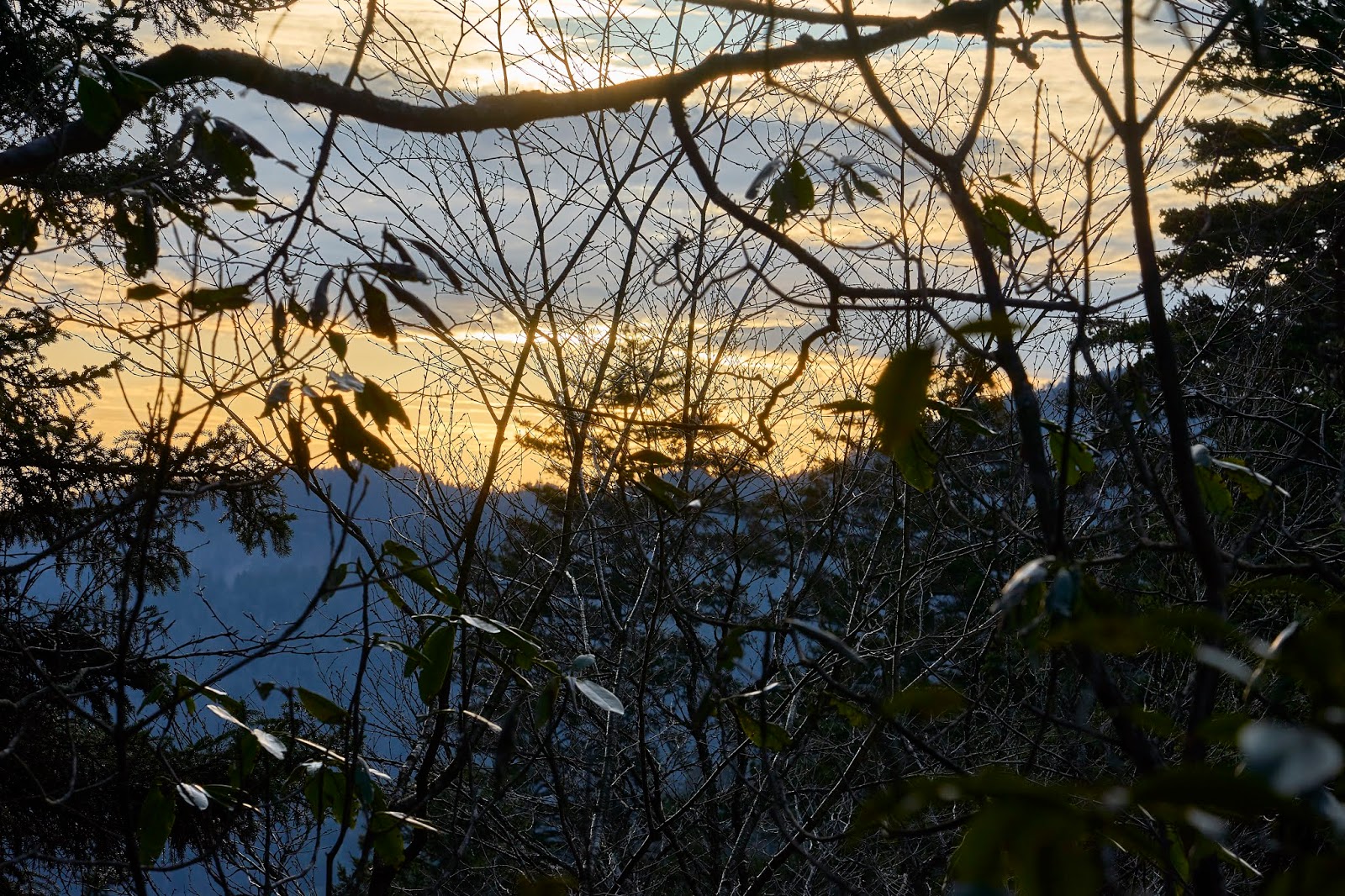
Blue hour with some crepuscular rays

I stayed up late enough to enjoy the stars (and see Mercury), but soon it was time for bed.

I woke up the next morning and enjoyed my coffee and the quiet morning, then packed up and headed back towards the car. My plan was to take the only bike friendly trail in the actual Red River Gorge down to a different road and then around to my car. I knew the trail was steep, but I thought I would be able to ride at least part of it. But, I'm not a very good mountain biker and the trail was very overgrown making it hard to see obstacles. I ended up pushing the bike the whole 2 miles down to the road and then had an easy 5ish mile ride back to my car. 

This ended up being a very good test for bikepacking. I learned that I am much more a gravel road and double track rider vs single track. I also learned that I need to work my bicycle leg strength since the ups seemed to work my legs more than steep hiking does. So, not only a good trip, but I learned something as well.

Friday, May 29, 2020

Appalachian Trail to Cataloochee

Great Smoky Mountains 
Trailhead: Newfound Gap
5/13 - 5/18/20 (5 nights)
2020 bag nights: 11

The road to Cataloochee is closed for construction, so the only way to get there is long hikes. I liked the idea of having the whole valley to myself :) I originally was thinking of hiking in from Polls Gap off Balsam Mountain Road, but the Blue Ridge Parkway was closed so I could not get there. Then while poking around on the park website I noticed a message that said you could pitch a tent near the AT shelters. Normally you have to sleep in the shelters unless you are an AT thru-hiker, so I usually avoid the shelters since I don't like people and I'm not a fan of the shelter mice. But if I could pitch a tent (actually hang a hammock) then maybe it would be ok. So, I decided to do a longer trip and see a new part of the park. 

Overview of trip
Newfound Gap => Pecks Corner Shelter => Laurel Gap Shelter => Pretty Hollow (#39) => Enloe Creek (#47) => Icewater Spring Shelter => Newfound Gap

Caltopo says 68 miles and 11500' elevation gain/loss


The weather forecast looked good for the ridge part of the trip


I got to Newfound Gap around 1 pm, it was grey and a little drizzly, but nice hiking weather. 

There were a ton of dayhikers going to Charlies Bunion or The Jumpoff. One of the dayhikers was a solo young woman with a dog. I like to politely call out dogs on the trails, so I mentioned that if a ranger saw her she was going to get a large ticket. She stuttered a bit and said it was a service dog. I decided not to mention that it was off leash and did not have a vest or anything :)

When I got to the Icewater Spring Shelter, there was this message, so the tent thing made sense. 

Nice view from the Icewater Spring Shelter

I continued on to Charlie's Bunion looking down into Tennessee

There were a couple people there, but thankfully it was not crowded. I suspect this bird was hanging out looking for dropped snacks.


A little farther down the trail is a nice view into North Carolina

Trilliums

I got to the Pecks Corner Shelter around 6 pm. The Shelter is down the hill a little bit and felt very closed in, basically a flat spot was carved out of the side of the mountain, so there isn't much space. There was a nice piped spring a little farther down the mountain. I would not stay here again. 

There were two guys staying in the shelter when I got there, they had some crappy music playing, so I talked to them for a little bit, but turned in early to read a bit. 
Sunset view through the trees at Pecks Corner Shelter. 

I woke up in the clouds, it was a little frustrating since it was obvious that there were potentially nice views, but I just could not see anything. 

The AT though the trees

As I dropped off the ridge, the views began to improve


I got to the Laurel Gap shelter around 3 pm and two guys were already there. I talked to them a bit while I tried to decided if I wanted to keep walking to Mt Sterling (about 5.5 more miles). I decided that I did not feel like hiking that much, so I set up camp down the hill from the shelter and then chatted with the guys for a bit. They were both professors from Auburn, so we talked about online teaching and if there would be in-person classes in the fall. 

The Laurel Gap Shelter was a much more pleasant place than the Pecks Corner shelter. It felt like there was some elbow room, the only drawback was the water was way down the hill and was a creek so I had to look a bit to find a nice pour off to fill my water bottles.

Woke up to another beautiful day. Higher up there had been a recent snow storm so most of the flowers were beaten down. A couple thousand feet lower and it was wildflower heaven. 


I had hiked the Mt Sterling Ridge trail about five years ago, but did not really remember it. It turned out to be an awesome stretch, gently rolling with a lot of open forest, no "views", but very pretty.

There were bluets everywhere, so tiny, so pretty

Red Trillium

Ragwort?

Painted Trillium

I dropped off Mt Sterling Ridge on the Pretty Hollow Trail. As you get lower, the creeks begin to get bigger. 

Fleabane

I was cruising along when there was a crashing noise off to the side. I looked up to see one bear running down hill (away from me) and another bear standing up to see what the fuss was. I tried to get my camera up, but he quickly figured out I was human and moved down the hill. As many bears as I have seen in the park, this is the best photo I have got. I wish he had paused for 3 more seconds :)

Smaller wildlife


I got setup up and Site #39 and headed down to Cataloochee. This is the Palmer Chapel. 


I was hoping to see some elk in the fields (or more bears), but it was very warm in the sun. 


Near where the pavement ends was a sign to the Palmer Cemetery. After a short, but steep hike I was there. I would guess there were about 100 graves, some relatively new and a lot that were old enough you could not make out any of the writing. 

Elijah Messer lived from 1844 - 1936. His wife Christine Messer lived 1847 - 1883. Their daughter Chanie lived from 1873 - 1880. Once again I am struck by how young people were when they died. 

I had never seen something like this before, a sundial on top of Chanie's gravestone

Mollie (Oct 1877 - Jul 1878), daughter of W.H. and S.A. Caldwell. There is a Caldwell Fork on the other side of the valley that is likely named after this family. 


Looking down the hill towards Cataloochee Valley

Hiram Caldwell Barn


Caldwell House

I headed back to the campsite where I met three guys from Lexington. I've ran into lots of people hiking, but this was the first time I met someone from home. They were really nice guys, I got back to the campsite and was really hot, I made an off-hand comment about buying a beer from them, but since it was their 2nd night I was joking. One of them said he had two beers cooling in the creek and he would give me one. I offered to actually pay, but he refused. The beer (West Sixth IPA) was great :)

Another great morning, I said farewell to the 3 guys as they left to head back to Mt Sterling for their last night. I headed up the Palmer Creek Trail towards the Balsam Mountain Road. 


After a long road walk, I came to this bridge and the Beech Gap Trail. I soaked my feet as I ate lunch. 


Big trees 

I got to Enloe Creek (Site #47) around 6 pm and had a bit of a panic. It is a very tiny campsite squeezed in between the side of the mountain and the gorge of the creek. It is the only campsite I have seen in the Smokies that is bad for hammocks. I actually pulled out the map and started thinking about hiking another 5ish miles and 1500' up and down to the next site before I decided I could make it work. It was a stretch, but I managed. 


Another nice day, but going to be warm. 

No idea what this is, but I thought the leaves were very striking. 

I also figured they would look good in B&W.


Backside of a trillium


About this point, I passed through a plateau that was covered with trilliums. I took some photos and as I started to move down the trail, I caught motion out of the corner of my eye. I turned and saw a coyote and then I heard yipping/whimpering farther down the hill. The coyote looked at me and started to go past towards the noise and then panicked and ran up the hill away from my and what I assume was her litter. I left the area and her alone. I have heard coyotes at night in the park, but never seen one. I wish she had paused a moment so I could get a photo. 

The Hughes Ridge trail was great.

Back on the AT and looking down on NC.


Yellow Trout Lily

I paused at this great view and talked to a couple dayhikers for a bit. They like to do big miles, so today they were doing a 25ish mile loop. 


Back to Charlies Bunion with better skies

Mt LeConte in the distance

There were a couple people there, but again not crowded. This guy offered to move when he saw my camera, I thanked him but said there was no need. He provided a little bit of perspective. 

Icewater Spring Shelter was crowded. There were a couple thru-hikers and a young couple from Michigan sleeping in the shelter and a bunch of people scattered around the broader area. I talked to some people and enjoyed the view with my dinner.

While I was eating, this deer came out of the woods. He was showing no fear as he wandered the area picking at leaves. I wish the beers and the coyote had stayed this still :)

It poured overnight and was still dripping in the morning. Given the weather, I was surprised how many dayhikers were out, it was obvious they weren't going to see anything. I thought it would have been a perfect day to go find a waterfall down low vs. a nonexistent view. 

I got back to my car in a little more than an hour and changed in the parking lot ...

... and then had an easy drive home.